 All directions are North from here.
Alan in Antarctica
All directions are North from here.
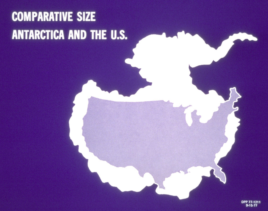 Antarctica is bigger than the United States.
 We are on Ross Island, approximately 80 km (50 miles) east-west and 80 km (50
miles) north-south. The Dry Valleys are to the West and the Ross Ice Shelf
touches the Island.
We are on Ross Island, approximately 80 km (50 miles) east-west and 80 km (50
miles) north-south. The Dry Valleys are to the West and the Ross Ice Shelf
touches the Island.
 Ross Island. We are at the southern tip, at the end of Hut Point
Peninsula, so-called, because Scott's Discovery Hut from his expedition to the South Pole
is just here. Mt. Erebus is
the tallest mountain on the Island.
Ross Island. We are at the southern tip, at the end of Hut Point
Peninsula, so-called, because Scott's Discovery Hut from his expedition to the South Pole
is just here. Mt. Erebus is
the tallest mountain on the Island.
 Erebus Bay, to the west of Ross Island, showing the route we took on the
Sea Ice School trip.
Erebus Bay, to the west of Ross Island, showing the route we took on the
Sea Ice School trip.
 Hut Point Peninsula. We are at McMurdo Station. Scott Base is the
New Zealand research station, with 16 people now. We landed at the place
marked Ice Aerodrome.
Hut Point Peninsula. We are at McMurdo Station. Scott Base is the
New Zealand research station, with 16 people now. We landed at the place
marked Ice Aerodrome.
NCAR runs a high resolution nested version of Polar MM5 every 12 hours, that I use for weather forecasts here. It is called the Antarctic Mesoscale Prediction System (AMPS).
The latest webcam image from Scott Base, next to McMurdo.
 August climatology, from the McMurdo weather channel.
 Sunrise and sunset, Aug. 22, 2004. The second line has a typo - it should
be August 23. While these are the official times of sunrise and sunset,
the sky starts to get bright three hours before sunrise and we can see light
inthe sky for three hours after sunset. We cannot actually see the sun at
McMurdo yet, as it is blocked by a mountain. I understand that we will
actually be able to see the sun here on Sept. 10.
Sunrise and sunset, Aug. 22, 2004. The second line has a typo - it should
be August 23. While these are the official times of sunrise and sunset,
the sky starts to get bright three hours before sunrise and we can see light
inthe sky for three hours after sunset. We cannot actually see the sun at
McMurdo yet, as it is blocked by a mountain. I understand that we will
actually be able to see the sun here on Sept. 10.
 Yesterday's weather summary, Aug. 22, 2004.
 Today's weather discussion, Aug. 22, 2004.
 Weather forecast, Aug. 22, 2004.
 Windchill of -59°C
(-74°F)
on Aug. 23, 2004. Luckily, we did not have to spend much time outdoors
that day.
Windchill of -59°C
(-74°F)
on Aug. 23, 2004. Luckily, we did not have to spend much time outdoors
that day.
 Windchill
of -66°C
(-87°F) on
Aug. 27, 2004. I went on an hour town tour that
day, and it did feel cold.
Windchill
of -66°C
(-87°F) on
Aug. 27, 2004. I went on an hour town tour that
day, and it did feel cold.
 The weather of Aug. 31, 2004, one of the colder days here.
 The weather of Sept. 4, 2004, an even colder day.
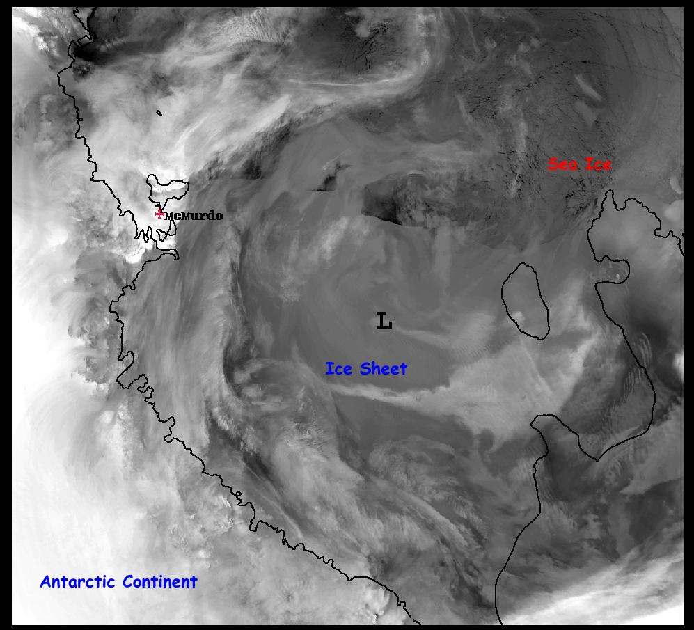 Satellite image, 4 a.m., Sept. 6, 2004, showing the ice shelf,
floating sea ice, and clouds over part of the region.
Satellite image, 4 a.m., Sept. 6, 2004, showing the ice shelf,
floating sea ice, and clouds over part of the region.
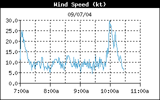 We went to launch an ozonesonde this morning, Sept. 7, 2004, and just as we got
the balloon inflated, a huge wind came in at 10 a.m., and we had to scrap the
balloon and the launch. I think it was just Mother Nature saluting me on
my birthday.
We went to launch an ozonesonde this morning, Sept. 7, 2004, and just as we got
the balloon inflated, a huge wind came in at 10 a.m., and we had to scrap the
balloon and the launch. I think it was just Mother Nature saluting me on
my birthday.
 A rather low wind chill on Sept. 23, 2004.
Where we work - the Crary Lab, Cosray
 Our wing of the Crary Lab, center, next to the loading dock. The Chalet is
on the left.
Our wing of the Crary Lab, center, next to the loading dock. The Chalet is
on the left.
 In my office. I have my laptop set up in here.
 Linnea, Lou, and Jen in our lab, where we prepare the ozonesondes.
 While I held up the pipette for the picture, I actually was using it to add
solutions to the ozonesonde as I conditioned it. This is the first lab
work I have ever done in my professional career.
While I held up the pipette for the picture, I actually was using it to add
solutions to the ozonesonde as I conditioned it. This is the first lab
work I have ever done in my professional career.
 The setup where I condition the ozonesondes prior to launch.
 An ozonesonde showing the anode and cathode cells, and the pump that pumps the
air through them.
An ozonesonde showing the anode and cathode cells, and the pump that pumps the
air through them.
 The other side of the ozonesonde, with the electronics.
 Cosray, on the road to Scott Base, Sept. 12, 2004.
 Cosray - the cosmic ray observatory where we receive transmissions from the
ozonesonde to back up the main reception in the Crary Lab.
Cosray - the cosmic ray observatory where we receive transmissions from the
ozonesonde to back up the main reception in the Crary Lab.
 Me monitoring the Aug. 25 flight at Cosray.
 The instruments at Cosray. These are the latest technology, including a
Toshiba T1000LE laptop. Behind it on the right are the cassette tape
recorder for backup and under that the modem. On the left is the radio
receiver, and behind it the two controls for moving the antenna up and down, and
side to side.
The instruments at Cosray. These are the latest technology, including a
Toshiba T1000LE laptop. Behind it on the right are the cassette tape
recorder for backup and under that the modem. On the left is the radio
receiver, and behind it the two controls for moving the antenna up and down, and
side to side.
 On September 5, 2004, I gave a Science Lecture in the Dining Hall to more than
100 people. It was fun to give a talk on that topic in such a cold place.
On September 5, 2004, I gave a Science Lecture in the Dining Hall to more than
100 people. It was fun to give a talk on that topic in such a cold place.
 I ended with the Hummer graffiti slide.
 A number of people stayed around afterwards to ask more questions.
Volcano lecture
 I also gave a lecture on volcanic eruptions and climate on Oct. 3, 2004.